- Overview
- Trip Outline
- Trip Includes
- Trip Excludes
- Gallery
- Reviews
- Booking
- FAQ
Highlights
- Explore mesmerizing Shey Phoksundo Lake, which is crucial for its crystal clear water and turquoise shape.
- A unique camping experience together with the various landscapes of the area and its hidden treasure.
- Buddhist’s holy place, Crystal mountain, and Shey Gompa observe the unique Bon Buddhist culture.
- High passes over 5000 meters extraordinary mountain views, meet locals, and visit monasteries.
- Visit the medieval village of Saldang and nomad camps at Dho Tarap, the highest human settlement in the world.
- Explore diverse flora and fauna in the Shey Phoksundo National Park.
The Dolpo region is familiar with the Tibetan Plateau, but it is yet to be unexplored. It has maintained its natural beauties although the territory is less frequent by the waves of modernization. However, making you an essential destination for trekkers who admire the value of serenity. Upper Dolpo Trek is a restricted area only opened for tourism since 1989. It belongs to the Shey Phoksundo National Park, and the Upper Dolpo trek route usually goes above 4000 meters, and this unknown land influences the Tibetan culture. So, this is a complete guide of Upper Dolpo trekking that helps you to plan a trek to Upper Dolpo with a one-in-a-million experience.
The trail goes on the way to leaving a small airstrip at Juphal and passes through the settlements. The views of the forest and high snow-capped mountains get to the deepest Shey Phoksundo Lake, which lies at 3600 meters above sea level. Meanwhile, the Kang – La Pass connects the Phoksundo valley and Shey Gompa. The Kang – La Pass is the highest point of the trek where you may see the beautiful mountains and landscapes. The Upper Dolpo trek joint with a visit to the Shey Gompa after the exploration of the Shey Phoksundo Lake. Shey Gompa and the crystal mountain provide a retreat and personal charm with the serenity since it possesses.
Despite the natural beauties and impressive scenery, the trail brings you the hidden Saldang and Yangtser Gumpa, which is about the secret of Upper Dolpo no one is talking about. Hence, the journey makes you a beautiful retreat of the Upper Dolpo region.
Itineraries
First Day
Day 1: Arrival day (1,300 m)
Upon arrival at Kathmandu, you will greet and welcome by our agency’s representative in front of the Arrival gate with a Display board of Himalayan Exploration Treks then transfer to your Hotel.
Second Day
Day 2: Free day and Trek preparation.
During the free day, you may have a chance to visit the heritage site of Kathmandu valley. We conduct the pre-trip departure meeting regarding upcoming trekking peak climbing where you meet the trek guide and other team members. They will brief you about the team formation, equipment and nature of peak climbing and other necessary information.
Third Day
Day 3: Flight to Nepalgunj – (150m)
As per the flight schedule; about an hour superb airstrip to Nepalgunj from Kathmandu. It is crossing a whole range of the western part of the Himalayas like Langtang, Manaslu, Annapurna, and Dhaulagiri. Comparatively, it is warmer than Kathmandu. Nepalgunj lies near the Indian border.
Fourth Day
Day 4: Flight to Juphal – 2475m & Trek to Dunai.
It requires making a fight in Juphal in the morning. Forty-five minutes of amazing flight provides super visibility of Himalayan foothill, with views of Annapurna and Dhaulagiri mastiff. After reaching Juphal and arranging luggage and other kinds of stuff, then an easy walk to Dunai.
Fifth Day
Day 5: Dunai – Chhepka (2630 m) 6hrs walk.
The first day of the adventure takes a bit more time to set up all the luggage. As we cross a bridge over the Bheri River takes a left trail that leads us to Shulighat, the entry point of Shey Phoksundo National Park. The trail goes along the Phoksundo Khola, passing through the several small settlements to Chhepka.
Sixth Day
Day 6: Chhepka – Chunuwar (3170 m) 6hrs walk.
The trail goes gradually climbs up along the valley through the forest. The trail follows several small ups and downs paths; need to be cross the river over small bridges that lead you to Raichi for lunch. At one point between Raichi and Chunuwar, there is a dramatic point where two rivers of distinctly different colors merge to form a single Phoksundo River. Then we continue to walk to Chunuwar.
Seventh Day
Day 7: Chunuwar – Phoksundo Lake (3620m) 4hrs walk.
The trek goes steeply uphill for the first three hours. There is minimal vegetation, and hills are very dusty in the dry season. As we arrive at the view tower, we can see the highest waterfall in Nepal with a height of 107 meters, mind-boggling sceneries surrounding hills. Ten minutes uphill from the view tower, we can get the first glimpse of Phoksundo Lake. Then, the trail goes gradually descending through the pine forest to the small village of Ringmo.
Eighth Day
Day 8: Acclimatization and exploration day!!!
Today, we will admire the beauty of Phoksundo Lake and possibly hike a small village of Ringo and its Tibetan monasteries. The people of this area are following the Bon Buddhist known as pre-Buddhist too.
Ninth Day
Day 9: Phoksundo Lake – Forest Camp (3640m) 6hrs walk
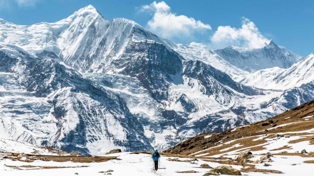
Ringo village is the boundary between Lower and Upper Dolpo. We will enter a restricted area of Upper Dolpo and follow the trail Oscar-nominated movie HIMALAYA, directed by Eric Valli. The trail is a salt trade route between the people of Dolpo and Tibet. The twisted trail is more adventures along the lake. As we reach a height of 4085 meters, after which it gradually descends through the dense forest and climbs up towards an open valley with a spectacular view of Kanjirowa Himal with an elevation of 6612 meters. Then, we reach a beautiful camping place.
Tenth Day
Day 10: Salla Ghari – Base Camp (4120m) 6hrs walk.
The Trekking trail is unique. We enter through high rock walls on both sides and cross a couple of streams without bridges. The river flows inside the gorge; the walk is uphill but not steep. There is wide open space on the river shore, with stony ground and thorny juniper bushes.
Eleventh Day
Day 11: Base Camp – Kang-La Pass – Shey Gompa (4320m) 7hrs walk.
The trail goes inclined steeply for the first two and a half hours over Sandy Mountain to Kang-La with an elevation of 5350 meters. The feet slid at every step, and altitude sickness may take hold at this point. After walking down the hill from the pass for about 4 hours, we get to Shey Gompa.
Twelfth Day
Day 12: Rest Day – Shey Gompa the crystal monastery.
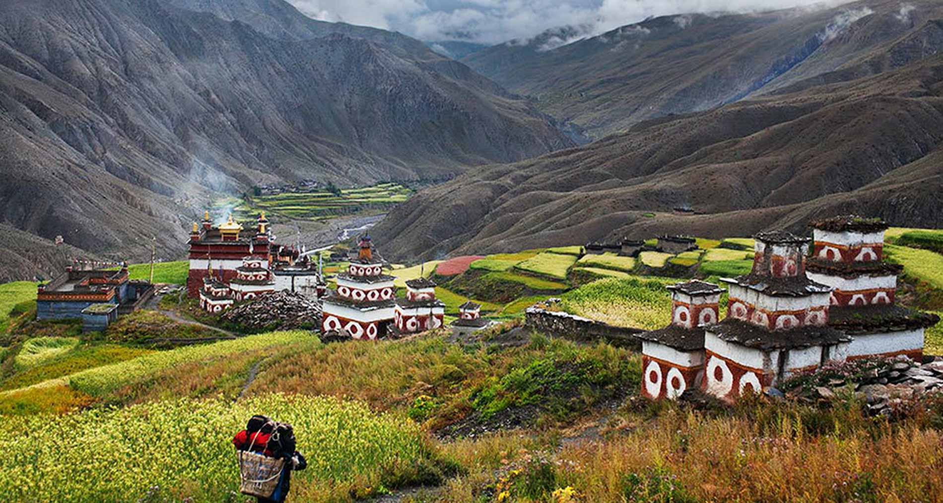
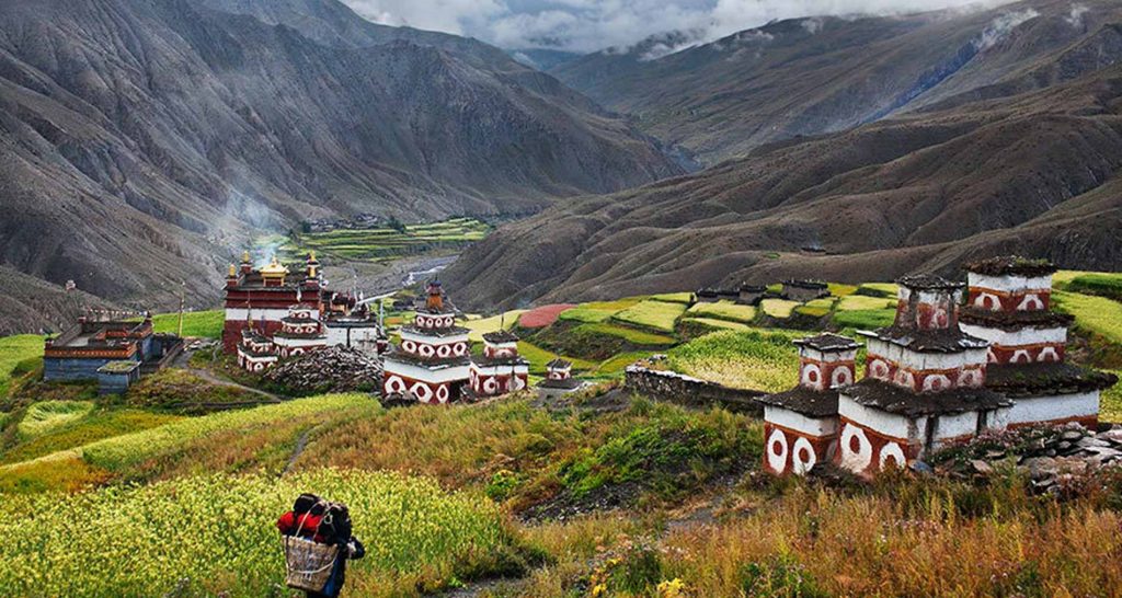
You can explore around Tsakang Gompa. It is not a monastery but a retreat. Tsakang had been a meditation center of many great lamas from Tibet. Shey Gompa belongs to the Chaiba community, followers of the Padmasambhava, and Kagyu sects. It was the first Kagyupa monastery, and its founder was the lama Ten-szin-Ra-Pa. The monastery was built during the 11th century. Shey is famous for its ancient Buddhist culture. In Dolpo, the ancient Tibetan way of life combines animism with the teachings of Buddha. Drutup Yeshe introduced Buddhism in the Dolpo valley. Many years ago, he came to Dolpo and came across a wild people whose supreme God was a ‘fierce mountain spirit.’ Crystal Mountain is to the west of the Shey monastery. It is an extraordinary mountain, indeed. Its contorted cliffs are laced with quartz and embedded with a wide variety of marine fossils. Shey Gompa stands above the confluence of Kwangju Nala and Yeju Nala. Near the confluence, there is a group of prayer mills turned by water wheels.
Thirteenth Day
Day 13: Shey Gompa – Namgung (4430m) 6hrs walk
We have to cross a pass with a height of 5,000 meters named Shey-La. Then the path begins to zigzag over bare rocks and coarse eroded soil. The trail subsequently descends to the pastures. It means our approach to Namgung.
Fourteenth Day
Day 14: Namgung – Saldang (4046m) 4hrs walk.
The trek leads us steeply climb up, feeling very hard as we arrive at 4700 meters pass. Then we walk down the picturesque village, Saldang. It is one of the largest villages of this region’s strategic location of the trade route to Tibet.
Fifteenth Day
Day 15: Saldang – Sibu (4000m) 6hrs walk.
The trek goes to pass through the terraced fields, stupas, chhortens, mani wall, monasteries, and several villages. We walk along the gorge where the bottom is populated with the green field of local barley. As we arrive at the campsite, we need to cross a knee-deep river twice. A beautiful open ground, thorny juniper bushes are only the vegetation.
Sixteenth Day
Day 16: Sibu – Jeng-La Base Camp (4480 m) 5hrs walk.
This is the last pass of the journey; mentality requires preparing. We walk up a mild horizontal along with a river site. We cross the river twice at some point in the trail for a long stretch. But towards ends become steeper. As we left valleys and villages, enter the barren hill, an almost highest camp of the journey.
Seventeenth Day
Day 17: Jengla Base Camp – Jeng-La Pass – Dho-Tarap (4200m) 7hrs walk
Today, we cross the last pass of the journey that walks up steeply uphill to the pass. We can see the beautiful sceneries of the Himalayas, including Dhaulagiri and the barren lands of Inner Dolpo. The trail goes down from the pass, gradually descending at first then steep down towards Tarap valley. Further 2 hours walk from Tokyo Goan, we get to Dho- Tarap (the highest village of the Dolpo.) and a junction from where the route diverges to Jomsom, Mustang, and Tibet.
Eighteenth Day
Day 18: Dho- Tarap – Serkam (3630m) 7hrs walk.
The trail leads you downhill in a windy gorge along the Tarap River. There are hanging ridges on both sides; sometimes, it even disappears between and under the hills. The trail goes through the narrow gorges with the rushing river. Many mules, horses, and Yak will encounter along the trail to transporting the goods. In the afternoon, the trail seems some improvement of construction and sees a modern steel bridge to facilitate the movement of people and animals.
Nineteenth Day
Day 19: Serkam – Shahar Tara (2280m) 5hrs Walk
The same course, walk along the river to the narrow gorge a gentle incline through the dense forest. Sometimes, several ups and downs appear along the trail due to the huge rocky stones that represent the quality of the trail and take attention while on trek possibility of slippery.
Twentieth Day
Day 20: Shahar Tara – Dunai (2109m) 5hrs Walk
The trail is easy to walk gradually inclined along the shore of the River. The trail sometimes climbs to the top of the hill and sometimes deep to the level of the River open space trail that leads us to Dunai.
Twenty First Day
Day 21: Dunai – Juphal (2404m) 3hrs Walk
The trail retrace the steps to Juphal while the journey to mountain. Just walk along the motorable road to Kala gouda. A steep climb up to Juphal passing through the cultivated rice fields
Twenty Second Day
Day 22: Juphal – Nepalgang – Kathmandu
Early morning, we take a flight to Nepalgunj. It is a wonderful 35- minute flight over the Himalayan foothills, with fine views of the main peaks including Annapurna and Dhaulagiri to the north. You then catch up on the connection flight back to Kathmandu.
Twenty Third Day
Day 23: Free day in Kathmandu.
The day can occupy as security day in case of flight interruption. Alternatively, you have a chance to explore the Heritage site of Kathmandu if you arrived on the scheduled itinerary.
Twenty Fourth Day
Day 24: Final Departure
You will be transfer to airport 3 hours before your scheduled flight to your home country
INCLUDESAll domestic flight, Hotel/Airport transfer |
|
Accommodations in Kathmandu with breakfast |
|
All accommodations in tents and all meals during the treks |
|
All necessary documentation and permits |
|
All ground transportation (as per mention in itinerary) |
|
Professional guide and porters |
|
A First Aid Kits |
|
Applicable Government Taxes |
DOESN'T INCLUDES
|
International Airfare |
|
Nepal Visa fee (advice to take accurate amount) |
|
Meals in Kathmandu (except breakfast) |
|
Personal Expenses e.g. phone calls, laundry, bar bills & extra porters |
|
Travel Insurance |
|
Tips for Guide and Porter. |
Be conscious. This trek will be over 3500 m in elevation. The possibilities of having an altitude illness usually begin at this altitude. But to prevent this, we have planned the itinerary to give you time to acclimatize as much as possible.
There’s nobody who’s going to suffer from altitude sickness. The younger and fitter people do not experience high altitude illnesses when they feel older and less fit. It’s not related to fitness or age. Speak to your private practitioner. Prescription medicines are available to help avoid the symptoms of altitude sickness. But go gently and listen to the body and be mindful of any changes and listen to your guide if he thinks that you have symptoms (which might not be apparent).
We will be able to collect your travel insurance policies and details before your trip. In case of emergency, we will be able to coordinate with your insurance company and helicopters company for emergency evacuation.
There is no doubt only be a First aid. We take a first-aid kit on every trip. We always advise you to make your own. Here’s a checklist of items you can bring, recommended. Vaccinations are not compulsory in Nepal; however, we suggest that you keep this checklist if necessary.
Yes, we only provide insurance to our staff. We recommend that you purchase insurance in your home country. Note: Insurance should cover medical and emergency evacuation.
No. The trails are well-known. You will not need crampons if you are not traveling in the mid-winter. Instead of the crampons, bring non-technical, lightweight spikes, are less costly and suit any shoe size.
Generally, we use local guides. Our guides have been numerous times on each trek to the relevant areas. All are qualified, competent, versatile, and certified licensed guides with the Government of Nepal.
If you use a porter, there are two advantages:
1. You can enjoy your trek entirely without carrying a heavy backpack.
2. Another is to increase the local communities’ income.
Yes, of course. We ensure that our staff is well insured.
Related Trips

There are no reviews yet.